
Aspley is a classic middle-ring north Brisbane suburb. About 13 km from the CBD up Gympie Road, inside the Brisbane City Council area, built out with post-war and brick-and-tile houses on full blocks, anchored by the Aspley shopping and homemaker precinct on the highway. It has no train station of its own. Commuters drive or take the bus down Gympie Road, and the nearest rail is on the Caboolture line at the neighbouring suburbs. It is neither a glamour suburb nor a problem suburb, which is exactly why a buyer wants the numbers, not the vibe.
We pulled three years of sales, the schools and catchments, the last 12 months of recorded offences, the flood overlays and the census. Here is what they say. We stopped the price window at 2023 on purpose, because anything older drags in COVID-era distortion and turns a clean story into a noisy one.
Prices: a million-dollar house suburb since 2024
| Year | Houses sold | Median sold | P25 to P75 |
|---|---|---|---|
| 2023 | 180 | $920,000 | $818K to $1.08M |
| 2024 | 176 | $1,101,500 | $986K to $1.30M |
| 2025 | 214 | $1,200,000 | $1.01M to $1.40M |
| 2026 to June | 62 | $1,373,000 | $1.28M to $1.54M |
The 2023-to-2025 line tells the whole story. $920,000 to $1,200,000 in two full calendar years. That is +30 percent on the median, or about 14 percent a year. Aspley crossed the million-dollar house median in 2024 and has not looked back. The 62 houses sold so far in 2026 are medianing $1.37M, though that is a part-year figure and will move as more sales settle.
One thing held Aspley back for years: getting to work. The suburb has no train station, so for somewhere only 13 km from the city, people drive or catch a bus down Gympie Road, and Gympie Road clogs up at peak hour in 2026. The suburbs a few kilometres east, the ones with a station on the Caboolture line, passed the million-dollar mark before Aspley did. Aspley only got there in 2024. That reliance on the road is the biggest brake on the suburb, and a big reason its prices have trailed the train-line suburbs nearby.
Townhouses tell the same story at a lower altitude. 16 townhouses sold in 2023 at a median of $605K. 41 sold in 2025 at $820K. That is a +36 percent move in two years, which is what happens when an established suburb hits the price where small-block developers start building attached product. The demand side pushes the same way: buyers shut out of a $1.2M house, downsizers wanting to stay in the area and younger professionals after a newer, low-maintenance home all pivot to townhouses, which lifts the floor under them. If you are weighing a block for its split or townhouse potential, we pulled the council records on what actually happens when you subdivide in Queensland.
Looking at an Aspley house and not sure which school catchment the address actually falls in? Check the exact block, free:
Schools: a split high catchment, and one side is stronger
Five schools sit physically inside Aspley:
- Aspley State School (government primary, ICSEA 1107, 690 students). Well above the national average of 1000.
- Aspley East State School (government primary, ICSEA 1063, 849 students). Also above average.
- St Dympna's Parish School (Catholic primary, ICSEA 1105, 647 students).
- Aspley State High School (government, co-educational, ICSEA 1005, 1,144 students). A whisker above the national average, near the 49th percentile nationally.
- Aspley Special School (government special school, years 7 to 12, 142 students).
For state high school the suburb is split, and which side of the line you land on matters. Roughly two thirds of Aspley falls into Aspley State High School (ICSEA 1005, co-educational). The remaining third, in the suburb's west, falls into Craigslea State High School in Chermside West (ICSEA 1070, co-educational). Craigslea sits a clear step higher on ICSEA, so a family buying for the catchment should check the official Queensland Department of Education boundary at the specific address, not the suburb name. For reference, the top BCC state high catchments sit in the 1135-to-1145 ICSEA band and the lowest sits near 908, so both Aspley high options are mid-to-upper-middle of the Brisbane pack.
The primary catchment is also split. About half the suburb feeds Aspley State School (ICSEA 1107) and about a third feeds Aspley East State School (ICSEA 1063), both above the national average. Small western and southern edges fall into Geebung State School (ICSEA 1030) and Zillmere State School (ICSEA 890, below the national average). Anyone buying for a particular primary catchment should confirm the boundary at the exact address on the Queensland school catchment finder rather than the suburb centroid.
Crime: broadly flat year on year, and the headline number is a retail effect
We mapped every recorded Queensland Police Service offence to its ABS meshblock and counted only the meshblocks that sit inside Aspley. Here is the 12-month picture to April 2026.
| Offence type | 12-month count |
|---|---|
| Other theft (excl. unlawful entry) | 317 |
| Traffic and related offences | 67 |
| Assault | 49 |
| Drug offences | 49 |
| Unlawful entry (burglary) | 48 |
| Other property damage | 46 |
| Fraud | 32 |
| Good order offences | 29 |
| Unlawful use of motor vehicle | 28 |
| Other offences against the person | 9 |
| Miscellaneous offences | 8 |
| Weapons Act offences | 6 |
| Trespassing and vagrancy | 6 |
| Handling stolen goods | 4 |
| Robbery | 3 |
The first thing to understand is that "other theft" (317) towers over everything else, and that is a retail signal, not a residential one. Aspley is built around a large shopping and homemaker precinct on Gympie Road, and retail theft and shoplifting are recorded to the meshblocks those shops sit in. It inflates any headline "total offences" figure for the suburb and tells a residential buyer almost nothing about their street.
The metric a residential buyer should actually look at is unlawful entry (residential burglary) and motor vehicle theft. Here is the year-on-year comparison.
| 12-month window | Unlawful entries | Motor vehicle thefts | Total recorded offences |
|---|---|---|---|
| Apr 2024 to Apr 2025 | 51 | 25 | 708 |
| Apr 2025 to Apr 2026 | 48 | 28 | 702 |
The honest read is that Aspley is broadly flat. Total recorded offences barely moved (708 to 702). Residential burglary edged down (51 to 48) and motor vehicle theft edged up (25 to 28). None of those moves is large enough to call a trend in either direction. This is not a suburb where the crime line is running away.
Flood: about 8 percent of properties touch a flood layer
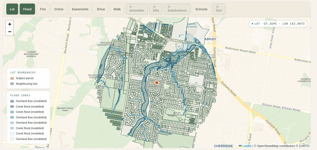
Aspley has a contained flood story. 82 of 981 properties (8.4 percent) intersect at least one Brisbane City Council Flood Awareness layer. The exposure clusters around the creek and overland flow paths that run through the suburb:
- 68 properties sit in a creek flood awareness area, of which 34 carry a High or Medium creek rating and 6 are rated High.
- 54 properties sit inside the recorded February 2022 historic flood footprint.
- 19 properties have an Overland Flow classification, where water does not need a creek to pond on the block.
For about 92 percent of the suburb the flood overlays are clean. For the 8 percent that are exposed, the exposure is concentrated along the creek and low-lying lines, not scattered at random. This is the kind of suburb where the address matters far more than the postcode for flood, which is also why suburb-level flood claims tend to mislead in both directions.
Who lives here: the census profile
The 2021 ABS census paints Aspley as a settled, owner-occupier, family suburb rather than a renter or investor one:
- Population 12,912, median age 43 (older than the Brisbane median, consistent with established family stock).
- Median weekly household income $1,838 and a median monthly mortgage of $2,000.
- Of 5,072 occupied private dwellings, 69.2 percent are owner-occupied (1,828 owned outright plus 1,684 with a mortgage) and 23.9 percent are rented.
- The dwelling mix is 3,680 houses and 1,190 townhouses, against just 21 flats or apartments. This is a house-and-townhouse suburb with almost no apartment stock.
The high owner-occupier share and older median age are why stock turns over slowly and why the price line has been so steady on the way up. It also explains the near-absence of unit sales: there is barely any unit stock to sell.
Rental yield: low 3 percent on a house
QLD RTA bond data for postcode 4034 (which also covers Zillmere, Boondall, Carseldine and Geebung, so read it as a postcode figure, not Aspley alone), most recent quarter to December 2025:
- 3-bedroom house: $680 per week median
- 4-bedroom house: $800 per week median
- 3-bedroom townhouse: $650 per week median
- 2-bedroom flat: $580 per week median
Against the 2025 Aspley house median of $1.2M, a 3-bedroom house at $680 per week is a 2.95 percent gross yield. A 3-bedroom townhouse at $650 per week against the 2025 townhouse median of $820K is a stronger 4.1 percent gross. The pattern is the usual one for inner-middle ring Brisbane: houses are a capital-growth hold on a thin yield, and the attached product carries the better rental return. Aspley is not a house yield play.
The honest answer
Is Aspley a good suburb? It depends on what a buyer is solving for.
- For an owner-occupier who wants a full-block house, quiet established streets, a major shopping precinct on the doorstep and a 20-to-30 minute run to the CBD by car or bus: it fits, with the caveat that the house median is now $1.2M and rising, and there is no train station, so commute is road and bus dependent.
- For a family chasing schools: check which side of the line you are on. The Craigslea State High catchment (ICSEA 1070) in the suburb's west is a clear step above the Aspley State High catchment (ICSEA 1005) that covers most of the suburb, and the primary catchments range from ICSEA 1107 down to 890 depending on the street.
- For a yield-focused investor: a house here yields in the low 3s and is priced like the rest of north Brisbane. Townhouses give a better return. No house yield edge either way.
- For anyone near the creek and overland flow lines: get the property-specific flood history before bidding. The 2022 event touched 54 properties in this suburb.
Aspley in 2026 is a fully priced, owner-occupier-heavy, north Brisbane house suburb with a split school catchment, flat residential crime and small, contained flood pockets. It is neither a hidden gem nor a trap. The data argues for honest, address-level due diligence rather than a yes-or-no on the suburb name.
Methodology
- Sales: median sold prices computed from recent residential sale records, matched to G-NAF address PIDs inside the Aspley suburb boundary (postcode 4034). $200K to $5M filter to remove obviously erroneous rows. Houses only for the year table; townhouses called out separately; units omitted as too thin to median.
- Schools: ACARA MySchool ICSEA snapshot. Only schools physically inside the suburb are listed, with ICSEA taken from the school record.
- Catchments: Queensland Department of Education release. Catchment splits determined by spatial intersection of each catchment polygon with the Aspley suburb boundary.
- Crime: Queensland Police Service recorded offence records, meshblock-coded, for the latest 12 months and the prior 12 months. Only meshblocks spatially inside Aspley are included. Records begin mid-March 2024.
- Flood: Brisbane City Council Flood Awareness Map (creek, overland flow and February 2022 historic event layers), spatially intersected with G-NAF property points inside the suburb.
- Census: ABS 2021 Census, Aspley SA2. Population, age, income, tenure and dwelling structure.
- Rentals: QLD Residential Tenancies Authority bond statistics, postcode 4034, most recent quarter.
Weighing up the north side? See our Boondall and Sandgate deep dives for the neighbouring suburbs on the same numbers, then run a specific Aspley address through our flood risk tool. For the wider Brisbane picture, see which streets carry the worst flood risk and the suburbs where recorded crime is falling, or browse all our Queensland suburb research.
Want the same check on a specific address in Aspley, or any other address in Queensland? Try it below.