
Scarborough is the top of the Redcliffe peninsula, the waterfront and marina end that wraps around the northern tip into Moreton Bay. About 30 km north of the Brisbane CBD, it sits in the Moreton Bay council area, not Brisbane City, which matters for rates, planning and flood mapping. It shares its postcode, 4020, with Redcliffe and Newport, so a postcode search blends three different suburbs together. Everything below is filtered to the Scarborough suburb boundary on its own, because the three are not interchangeable on price.
We pulled three years of house and unit sales, the schools and catchments, the last 12 months of recorded offences, the flood overlays and the census. Here is what they say. We stopped the price window at 2023 on purpose, because anything older drags in COVID-era distortion and turns a clean story into a noisy one.
Prices: a million-dollar house suburb since 2023
| Year | Houses sold | Median sold | P25 to P75 |
|---|---|---|---|
| 2023 | 131 | $1,000,000 | $770K to $1.30M |
| 2024 | 141 | $1,000,000 | $850K to $1.32M |
| 2025 | 149 | $1,150,000 | $915K to $1.39M |
| 2026 to June | 28 | $1,283,500 | $1.11M to $1.44M |
Scarborough started this window already a million-dollar house suburb. The median sat at $1,000,000 across both 2023 and 2024, then stepped up to $1,150,000 in 2025, a +15 percent move on the median in a single year. That is a higher base than Redcliffe proper just down the peninsula, where the 2025 house median was $900K, and it reflects Scarborough being the waterfront, marina and bayfront end rather than the town-centre end.
The wide P25-to-P75 spread is the real tell here. In 2025 the middle half of house sales ran from $915K to $1.39M, nearly a half-million-dollar gap. Scarborough is not a uniform suburb. It holds modest post-war cottages on the inner streets and absolute-waterfront houses on the bay edge in the same postcode, and the median sits in the middle of a genuinely two-tier market. The street matters more than the suburb name.
Units and apartments are a thinner but rising story, and the early-year samples are too small to lean on. Only a handful of attached dwellings sold in 2023 and 2024. By 2025 the apartment market was active enough to read: 27 apartments sold at a median of $980K, and the 2026 partial figure is 30 sales at $1.15M. As on the rest of the peninsula, that high apartment median is beachfront stock with the bay out the front window, not the typical walk-up unit. Townhouses sat lower, with 17 selling in 2025 at a median of $870K. If you are weighing a block for its split or townhouse potential, we pulled the council records on what actually happens when you subdivide in Queensland.
Schools: an unusually clean catchment for the peninsula
Three schools sit physically inside the Scarborough suburb boundary:
- Scarborough State School (government primary, Prep to Year 6, ICSEA 1015, 776 students). Above the national average of 1000.
- Southern Cross Catholic College (Catholic, Prep to Year 12, ICSEA 1041, 1,653 students). The largest school in the suburb and a full primary-to-senior option.
- Australian Trade College North Brisbane (independent, Years 11 to 12, ICSEA 1026, 286 students). A senior trade-focused provider, not a general-intake school.
This is where Scarborough differs from Redcliffe just down the peninsula. Where Redcliffe is carved across several primary and two secondary catchments, Scarborough is almost entirely one catchment each way. For state primary, effectively the whole suburb feeds Scarborough State School (ICSEA 1015). For state secondary, effectively the whole suburb feeds Redcliffe State High School (ICSEA 1004, co-educational), the same high school that covers most of Redcliffe. Both sit just above the national average.
The practical takeaway is the easy one for once: a family buying in Scarborough for the state catchment lands in the same two schools almost wherever they buy inside the suburb. It is still worth confirming the official Queensland Department of Education boundary at the exact address, but Scarborough does not have the street-by-street catchment lottery that its neighbour does.
Crime: small numbers, up off a low base
We mapped every recorded Queensland Police Service offence to its ABS meshblock and counted only the meshblocks that sit inside Scarborough. Here is the most recent 12-month picture, to April 2026 (the date the recorded-offence data currently runs to).
| Offence type | 12-month count |
|---|---|
| Other theft (excl. unlawful entry) | 72 |
| Unlawful entry (burglary) | 41 |
| Other property damage | 30 |
| Drug offences | 28 |
| Traffic and related offences | 22 |
| Assault | 15 |
| Good order offences | 14 |
| Fraud | 10 |
| Unlawful use of motor vehicle | 8 |
| Weapons Act offences | 6 |
| Trespassing and vagrancy | 5 |
| Other offences against the person | 4 |
| Handling stolen goods | 3 |
| Miscellaneous offences | 3 |
| Robbery | 2 |
The first thing to notice is the scale. Scarborough records far fewer offences than Redcliffe down the peninsula, because it has none of the busy town-centre retail strip that concentrates public theft. The whole 12-month tally across the suburb is in the low hundreds. Even the largest category, "other theft", sits at 72, and on a residential tip like this a good share of that is opportunistic theft from parked cars and the foreshore rather than home break-ins.
The metric a resident actually cares about is unlawful entry (residential burglary) and motor vehicle theft. Here is the year-on-year comparison.
| Metric | Prior 12m | Latest 12m |
|---|---|---|
| Total recorded offences | 218 | 263 |
| Unlawful entry (burglary) | 36 | 41 |
| Unlawful use of motor vehicle | 13 | 8 |
The honest read is that recorded crime rose, but off a small base and not evenly. Total offences went from 218 to 263, up about a fifth, which in absolute terms is around 45 extra incidents across the whole suburb over a year. On the two metrics a home buyer weights most, the picture is mixed rather than alarming: residential burglary edged up from 36 to 41, while motor vehicle theft actually fell from 13 to 8. Recorded crime is up across much of the Brisbane region in 2025 and 2026, and Scarborough is part of that wider trend rather than a standout in either direction. At these small counts a handful of incidents moves the percentage a lot, so read the direction, not the decimal.
Flood: roughly a quarter of addresses touch a flood overlay
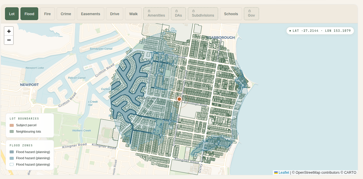
Scarborough is the low-lying tip of a peninsula with Moreton Bay on three sides, so flood and coastal-inundation mapping is worth taking seriously. We intersected every Scarborough address point against the Moreton Bay flood overlay. 232 of 979 addresses (23.7 percent) fall inside at least one mapped flood overlay, a slightly higher share than Redcliffe proper, which fits a suburb wrapped by water on its northern and eastern edges.
A clear word on what that number is and is not. The Moreton Bay overlay in our data flags whether an address sits in a mapped flood-affected area, but it does not grade severity the way the Brisbane City creek-and-river layers do, so we are not going to put a high, medium or low label on individual streets here. The honest read is that roughly one in four Scarborough addresses is flagged, three in four are clean, and on a bayside tip the flagged addresses cluster toward the low-lying and waterfront edges rather than scattering randomly. This is a suburb where the specific address matters far more than the postcode.
Looking at a Scarborough block near the water? The suburb average tells you nothing. Check the flood and storm tide overlay for that exact address, free:
Who lives here: an older, settled bayside profile
The 2021 census profile that covers Scarborough is the Scarborough - Newport SA2, so it blends Scarborough with neighbouring Newport rather than isolating Scarborough alone. On that basis the area had a population of 15,257, a median age of 49 (well above the Greater Brisbane figure, consistent with the long-standing retiree and downsizer pull of a bayside town), a median weekly household income of $1,658, a median monthly mortgage repayment of $2,100 and an average household size of 2.4 people. Of 5,561 occupied private dwellings, 2,349 were owned outright and 1,850 were owned with a mortgage, against 1,672 rented. This is a settled, owner-occupier-heavy, older profile, with houses (4,432) far outnumbering units (1,258) and townhouses (393) in the dwelling mix. Every figure here is from ABS Census QuickStats for the Scarborough - Newport SA2.
Transport: no station, and further from the line than Redcliffe
The Redcliffe Peninsula railway line opened in October 2016 and connected the peninsula to the Brisbane network, but the important nuance for a Scarborough buyer is that there is no train station in Scarborough, and there is no station anywhere on the peninsula tip. The line terminates at Kippa-Ring, which is the closest station. Because Scarborough sits at the far northern end, it is a longer drive or bus to Kippa-Ring station than from the Redcliffe town centre, so for most of the suburb the commute is road and bus dependent and proximity to Kippa-Ring is an address-level variable worth checking.
Rental yield: sub-3 percent on a house
QLD RTA bond data for postcode 4020, most recent quarter (December 2025):
- 3-bedroom house: $620 per week median
- 4-bedroom house: $775 per week median
- 2-bedroom flat or unit: $500 per week median
- 3-bedroom townhouse: $650 per week median
Against the 2025 Scarborough house median of $1,150,000, a 3-bedroom house at $620 per week is about a 2.8 percent gross yield. A 2-bedroom flat at $500 per week against the 2025 apartment median of $980K is about 2.7 percent gross, and a 3-bedroom townhouse at $650 against the $870K townhouse median is a stronger 3.9 percent. The pattern is the usual one for a pricier bayside suburb: houses are a capital-growth hold on a thin yield, and the attached product carries the better rental return. Note the rental data is reported at the postcode level, so it blends Scarborough with Redcliffe and Newport, while the sale prices above are the Scarborough suburb only. The yields here come out below Redcliffe’s precisely because Scarborough houses cost more for the same postcode rent.
The honest answer
Is Scarborough a good suburb? It depends on what a buyer is solving for.
- For an owner-occupier who wants the bay, a marina and foreshore lifestyle and a settled, older community at the tip of the peninsula about 30 km from the CBD: the appeal is real, with the caveat that this is already a million-dollar house median and has been since 2023, and there is no train station, so the commute is road and bus dependent.
- For a family chasing schools: Scarborough is the easy case on the peninsula. Almost the whole suburb feeds Scarborough State School (ICSEA 1015) for primary and Redcliffe State High (ICSEA 1004) for secondary, both above the national average, so you are not playing the street-by-street catchment lottery that Redcliffe has. Confirm at the address anyway.
- For a yield-focused investor: a house here yields under 3 percent gross, lower than Redcliffe down the road, because the houses cost more for the same postcode rent. Townhouses give a better return near 3.9 percent. This is a capital-growth address, not a house yield play.
- For anyone near the foreshore, the marina or the low bay edge: roughly one in four Scarborough addresses sits in a mapped flood overlay, and the exposure concentrates toward the water. Get the property-specific flood and storm tide check before bidding.
Scarborough in 2026 is the pricier, waterfront end of the Redcliffe peninsula: a long-standing million-dollar house market, a settled older population, an unusually clean school catchment for the area, modest crime numbers that ticked up off a low base, and real but concentrated flood exposure on the low-lying edges. The data argues for honest, address-level due diligence rather than a yes-or-no on the suburb name.
Methodology
- Sales: median sold prices computed from recent residential sale records, matched to G-NAF address points inside the Scarborough suburb boundary (postcode 4020, excluding Redcliffe and Newport which share the postcode). $200K to $5M filter to remove obviously erroneous rows. Houses only for the year table; units, apartments and townhouses discussed separately and flagged where samples are thin. The 2026 figures are partial-year and low-count and flagged as such.
- Schools: ACARA ICSEA snapshot. Schools listed are those physically inside the suburb boundary; catchment ICSEA values were cross-checked against the same school records.
- Catchments: Queensland Department of Education catchment polygons, intersected with the Scarborough suburb boundary. The primary and secondary catchments covering the suburb were both checked; each covers effectively the whole suburb.
- Crime: Queensland Police Service recorded offence records, meshblock-coded, for the 12 months to April 2026 and the prior 12 months for the trend. Only meshblocks whose centroid sits inside the Scarborough suburb boundary are included. Records begin mid-March 2024.
- Flood: Moreton Bay flood overlay, spatially intersected with G-NAF address points inside the suburb. The overlay flags presence in a mapped flood area but is not severity-graded in our data.
- Census: ABS 2021 Census, Scarborough - Newport SA2 (code 313051575), which blends Scarborough with neighbouring Newport.
- Rentals: QLD Residential Tenancies Authority bond statistics, postcode 4020, most recent quarter (December 2025). Reported at the postcode level.
Still building a Moreton Bay shortlist? Our deep dives on Redcliffe, Narangba and Redland Bay run the same price, crime and flood numbers, and you can test any specific address against the council flood overlays with our flood risk tool. For the wider Brisbane picture, see which streets carry the worst flood risk and the suburbs where recorded crime is falling, or browse all our Queensland suburb research.
Want the same check on a specific address in Scarborough, or any other address in Queensland? Try it below.